USAF Tests Mapping Technology With UAV Written 24 September 2019
24 September 2019
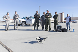
ExecutiveGov reports that “the U.S. Air Force’s 548th Intelligence, Surveillance and Reconnaissance Group and 9th Security Forces Squadron have partnered to test an artificial drone technology designed to map infrastructure.” On September 21, the Air Force “said...that the Hivemapper airborne video map program currently in beta testing at Beale Air Force Base in California works to record imagery and helps an unmanned aerial system to track change detection through visualization and analytic tools.” Hivemapper CEO Ariel Seidman said, “With deployments across the Air Force, the Air Force Research Laboratory and Air Force Special Operations Command to name a few, the Hivemapper team continues to...deliver capabilities in demand.” (Image: Small quadcopter test | USAF)
Full Story (ExecutiveGov)