NASA Tracks, Prepares For Hurricane Dorian Written 29 August 2019
29 August 2019
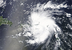
CNET News reports that “NASA and National Oceanic and Atmospheric Administration satellites are tracking” Hurricane Dorian as the weather formation “takes shape.” NASA’s Terra satellite has captured images of the storm, which “is making its way across the Atlantic and looks set to impact the Virgin Islands, Puerto Rico, the Bahamas and Florida.” (Image: NASA’s Terra satellite provides a visible image of Dorian | NASA Worldview, Earth Observing System Data and Information System – EOSDIS)
Full Story (CNET News)